
Beach Analysis
Beaches are vital to everyday life for residents of the Virgin Islands. Despite this, beaches are understudied and overexploited. To counteract this, CGTC launched a series of studies and research efforts to better understand these dynamic systems through characterizing their physical characteristics, track their long-term changes and predict how they may change in the future.
Beach Characterization
The first step in this endeavor is to build a solid knowledge foundation concerning our beaches. To accomplish this, we conducted beach surveys that looked at beach slope, how far in land waves go and characterized the dominate sand grain size of beaches across the Territory. We found, in general, that most sandy beaches can be characterized as having medium grain (0.25-0.5 mm/0.01-0.02 in) sand, has a primarily marine origin and an average slope of 9°.
Long-Term Shoreline Change
Our graduate student, Zoe Price, dedicated her master’s thesis to looking at how the shorelines of the US Virgin Islands have changed over the past decades. Using satellite imagery from 1954-2022, Price analyzed how shorelines have naturally shifted over time taking into consideration the possible impacts of natural disasters, such as Hurricanes Irma and Maria. She found beaches are naturally dynamic with shorelines shifting up and down the beach on a regular basis and that, in general, our beaches are mostly stable. This goes against the common sentiment that our beaches are eroding. In actuality, only a few beaches can be classified as such, and it has more to do with man-made disruptions to natural processes.
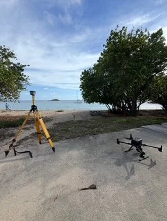
Seagrass Beds and Sediment Movement
Working off the progress made by Zoe Price, our second master’s student, Maya Hodder, is investigating how the presence or absence of seagrass beds may influence wave energy and, in turn, how sand moves within the beach ecosystem. To accomplish this, Hodder uses surveying methods linked with GNSS technology to track beach elevation along transects that both intersect and do not intersect seagrass beds. Data are collected during regular tidal conditions, as well as immediately after and in the days following high energy wave events, to quantify beach recovery time. Her monitoring sites include Lindbergh Bay and Lindquist Bay on St. Thomas.
Beach Access
According to the Open Shorelines Act, all beaches in the US Virgin Islands are accessible to the public. However, the law does not state that an access path to our beaches needs to be provided by property owners, unless it’s a hotel in some cases. To address and combat this, the Center has taken on a multi-year effort to visit all beaches in the Territory and characterize their level of access taking into consideration their physical and economic hurdles. We found that only %%% of beaches across the Territory are free and easily accessible while others have some topographic hurdle, making them primarily accessible by boat. Majority of beaches are behind some private property with no designated public access path, making them inaccessible to the public despite having the right to be on the beach. As we progress with this project, we hope to identify already existing access paths and propose locations for new paths.