
History of Hazards in the USVI
Author: Nikita Beck
The United States Virgin Islands has gone through a multitude of natural hazards that has left a lasting impact on the islands and culture.
The first recorded natural hazard event which had significant influence on the history of the Virgin Islands was the drought of 1733. On St. John, it was so severe that it led to the first successful slave rebellion in the Caribbean which occurred on November 23rd 1733. It took the joint armed forces of three nations to end the siege on the island’s Danish fort. To commemorate the freedom fighters march from Caroline to Fortsburg, the Virgin Islands celebrates Fortsburg Discovery Day, every year on the Friday following Thanksgiving. Following this drought, it was hypothesized that majority of the crops on St. John may never fully recover and the effects were still seen in the 1960s. This drought and others that happened during this time period encouraged some governors to investigate potential crops that could serve as drought mitigators to dampen the effects of this naturally occurring, but economically damaging, phenomena. The droughts and slave rebellion ignited rising tensions between enslaved peoples and the governing bodies, raising suspicions that any occurrence of a bushfire during a dry period was suspected of being caused by angry enslaved people.

Image depicting the tsunami in 1867 impacting the Charlotte Amalie harbor. Image from St. John Historical Society. Source: https://stjohnhistoricalsociety.org/vol-ix-no-2-october-2007-a-report-of-the-earthquake-of-1867-by-louis-van-housel/
The next recorded natural hazard with significant societal impacts was an estimated 7.5 magnitude earthquake in the Anegada Trench on November 18, 1867. The primary account of this event is from an American sailor, Louis van Housel, who depicted a reckoning that has been looming over the lives of many with stone church towers crumbling, exposed reefs from receding waters and two 7.6m (24.9ft) tsunamis that hit Frederiksted town. The entire event was so sudden and severe that as people tried to get to safety, some abandoned all hope and jumped into the raging sea or died of fright from seeing nature in ways they never had before. In a hopeful showcase of solidarity, regardless of color, people saved each other from the incoming waters with the goal of heading for higher land.

Kinghill Aquifer in St. Croix was heavily utilized during the drought from 1964-1967. Image from the U.S. Geological Service https://pubs.usgs.gov/ha/ha730/ch_n/N-PR_VItext5.html
In modern times, the first significant hazard that occurred was the drought that lasted from 1964 and ended in 1967. During this time, multiple wells were opened across St. Croix to serve residents of the area, but they were all eventually inundated by sea water due to there being no rain to replenish them. The Kingshill Aquifer, which is under central St. Croix, holds the highest potential for ground water in the territory and it is estimated the amount of water pumped out was tripled over the drought period. This was not aided by golf course owners who used what scarce water was available to keep their golf courses green. On St. John, the Cinnamon Bay spring was dry and scientists at the time proposed a practice of keeping some water in storage facilities to maintain the natural environment and keep the springs flowing.
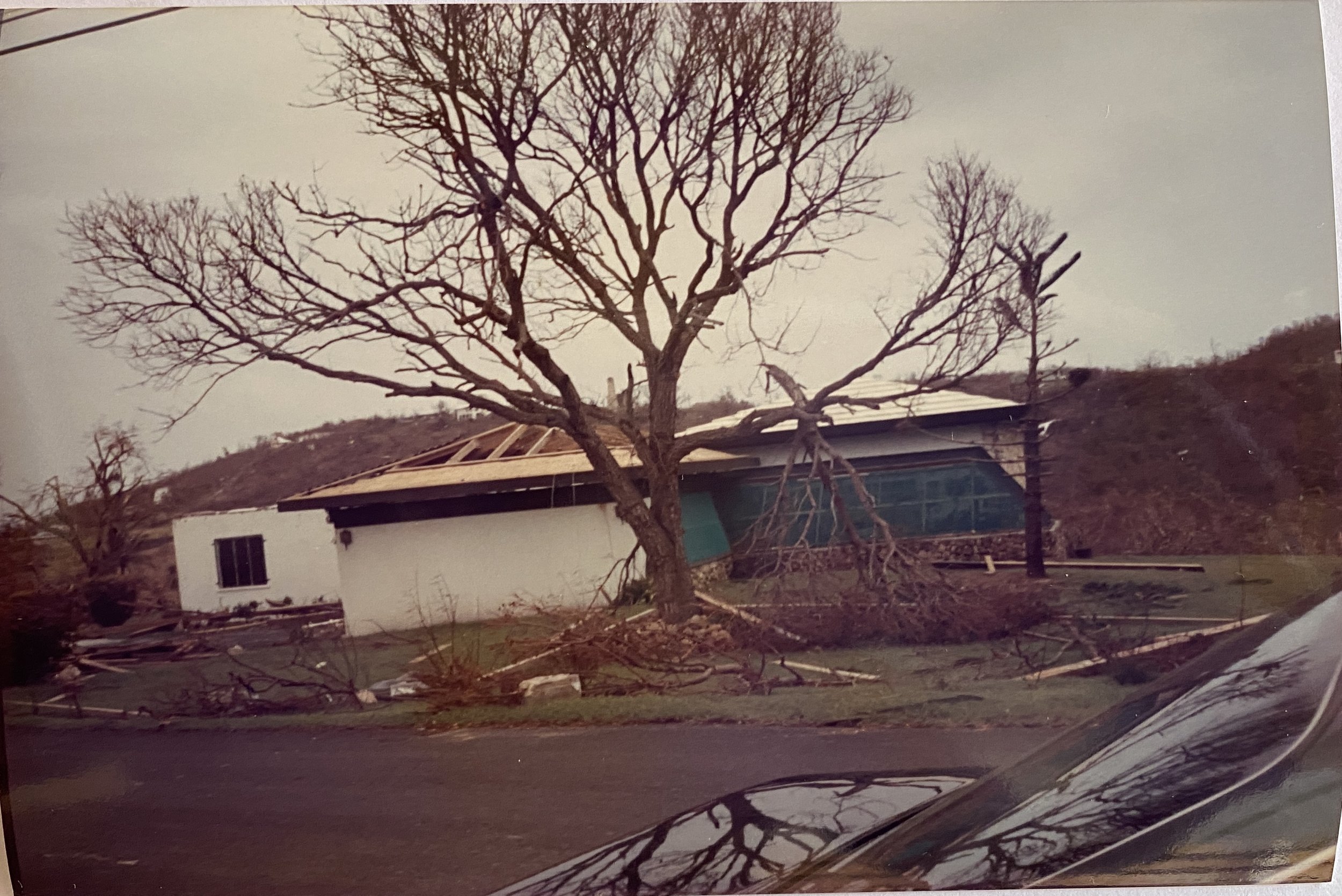
Hurricane Hugo September 1989, Category 4
Throughout history, hurricanes have been the primary hazard leaving a mark on the Territory due to their significant ecological and societal impacts. During and following these storm events, there are stories shared of fighting against winds to keep doors closed, long days waiting for power to be restored, and the anxiety of not knowing if life would ever be the same. Hurricane Hugo, which hit St. Croix in September of 1989, was a Category 4 hurricane which decimated many homes and buildings. As a result, this led to updates in the V.I. Code to help protect buildings from being destroyed by following storms. Hurricane Marilyn, which came almost 6 years later to the day, was a Category 2 hurricane that primarily impacted St. Thomas and St. John. For people that were on island during the event, they would swear Marilyn was at least a Category 4 hurricane, but according to the data available, it was a Category 2 on the cusp of becoming a 3. The discrepancy in category of wind speeds recorded and the damages felt is due to the topography of St. Thomas creating a tunneling effect where winds blowing between the island’s many hills speed up and incur more damage to buildings and nature alike. Based on the experiences of those who went through Hurricanes Marilyn and Hugo, there were more generators attached to homes since it was the only way to have power while the grid was being repaired. Throughout the Territory, residents became vigilant in hurricane preparedness at the beginning of every hurricane season so they would never be blindsided again.

Image from St. Thomas Source of flooding in the USVI, 2010
While not due to the impacts of a hurricane, in November of 2010, there was a never-before-seen flooding event On St. Croix with an estimated 7.04 inches of rain measured in Frederiksted. During this time, the entirety of Frederiksted was severely flooded. The flood waters were so intense, this region of St. Croix was cut off from the rest of the island as roads were completely impassible. One woman passed away during the event as she was carried away by the flood waters. Schools across the island were closed early to prevent residents from having to tread through the raging waters that were seen carrying debris and downed trees. Residents were left stranded, either from their cars stalling after taking in water or from the waters rising to a point they could no longer feasibly cross the destroyed roads.
The most recent major hazard event occurred in early September 2017, when Hurricane Irma hit the islands of St. Thomas and St. John, devastating the islands, and forcing residents and visitors to start the months long journey of recovery. Two weeks later, Hurricane Maria hit the island of St. Croix and extended the journey of recovery and resilience implementation for the territory after washing away whatever remained after Irma. While the territory has made considerable progress since the storms, there is still work to be done. A lesson quickly learned was the importance of having your own power supply, as residents were left without electricity for over 3 months. With so many households utilizing generators, there had to be PSAs to inform residents of their safe usage. Another valuable lesson learned was the understanding that we not only had to rebuild damaged structures, but they had to be rebuilt stronger whilst considering all the different types of hazards that happen here. This can be seen with homes on the market advertising their inclusion of hurricane shutters, automatic transfers for generators or solar and battery storage. People also looked at the buildings that survived the pummeling from the 2017 storms, took note as to why those survived, and applied those to new reconstruction projects.
Through learning about the history of hazards we can start to understand how the impacts of natural hazards affect us, not just ecologically, but also as a society. Throughout time, we can see the transformations these significant events had on our history, culture, and infrastructure.
The history of hazards in the US Virgin Islands is part of the research being done in the update to the USVI Hazard Mitigation and Resilience Plan.